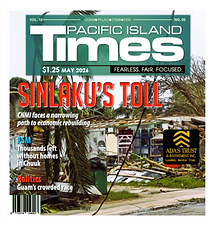
Damaging winds expected as early as Monday evening
- By Pacific Island News Staff
- Sep 8, 2018
- 3 min read
Governor Eddie Calvo and Rear Adm. Shoshana Chatfield, commander, Joint Region Marianas, anticipate placing Guam and the respective military bases in Condition of Readiness (COR) 3 at 7 p.m. this evening. At COR 3, damaging winds of 39-57 mph are expected within 48 hours. Please keep in mind, we anticipate the onset of damaging winds as early as Monday night so we are urging the community to take the weekend to prepare. Additionally, the National Weather Service is anticipating issuing a typhoon watch for the Marianas this evening. A typhoon watch means typhoon strength winds of at least 74 mph are possible within 48 hours. Weather conditions could change so it is important to have the most updated information. The Joint Information Center will continue pushing information about the storm as it gets closer. Closest Point of Approach As of 2 p.m., Tropical Storm Mangkhut was located 13.7 degrees north latitude and 161.5 east longitude; about 1125 miles east of Guam, with maximum sustained winds of 40 mph. The tropical storm will continue its westward track and is expected to intensify, possibly becoming a Category 4 typhoon by the time it reaches Guam, with Tuesday 11 a.m. being its anticipated closest appoint of approach (CPA). It is important to still prepare for worst-case-scenario, of a Category 5 typhoon.
Category 4 Typhoon is referred to as a “Very Strong Typhoon” with maximum sustained winds of 130-156 and peak gusts of 165-198 mph.
Category 5 Typhoon is referred to as a “Devastating Typhoon” with maximum sustained winds of 157-194 mph and peak gusts of 199-264 mph. A Category 5 typhoon has the ability to be life-threatening to those that do not prepare in advance.
Although the storm’s CPA is forecast for noon on Tuesday, Guam and the Marianas can expect damaging winds of 39 mph or more as early as Monday around 11 p.m. Don’t Wait - Use Today and Tomorrow to Prepare Upon completion of the following preparedness tips, it is important to take pictures of your home and around property before the storm approaches. These pictures can be used in the aftermath of the storm for insurance purposes, when damage assessments are conducted over the island.
INDOOR PREPARATIONS
Roll up carpets away from doors and windows
Make lighting supplies easily accessible
Unplug all appliances and ensure energy breakers are switched off once damaging winds approach (forecast to be by late Monday)
Make sure family members know where the emergency preparedness kits are at; stock up on non-perishable food items and water for your household, flashlights, first-aid kits, batteries, matches or lighters, portable stove, toiletries, etc. Visithttps://www.ready.gov/build-a-kit for more information on what to include in your supplies list
Secure important documents such as birth certificates, tax papers, and insurance documents and keep copies in a water-proof bag
Cover beds and furniture with plastic to prevent water damage
Stay up to date in the event there are changes in weather conditions
Remember to collect water for the toilets as well, keeping buckets with water in the bathroom in advance
Do your laundry now
OUTDOOR PREPARATIONS
Secure your home – put shutters on windows, completely board up your home
Make sure the gas valve is shut off once the storm approaches (forecast to be by late Tuesday)
Clear loose debris around your yard and store any items that may become airborne with heavy winds, before inclement weather arrives
Clear vegetation
Take down any temporary signs, including those for political campaigns, advertisements, and any other wooden or loosely placed items as these have the ability to lift in heavy winds and cause damage to life and property
Gas your vehicles and get fuel for your generators now while the weather is clear
Collect water in a 55-gallon drum, empty coolers or plastic containers now
Discuss your emergency plan with household members. Include pets as part of your plan. Those that live in substandard housing are advised to seek shelter once emergency shelters are operational. A complete list of available shelters will be provided by the Joint Information Center. Guam Memorial Hospital is making preparations for pregnant mothers. More information will be provided by the Joint Information Center. Those that rely on electricity to power machines for health reasons need to make arrangements now with a relative or neighbor with a working generator to stay with them early next week for the duration of the storm. Stay Up To Date with the Joint Information Center The Joint Information Center is the government of Guam, military and federal government’s clearinghouse for accurate information during emergencies. The following is a list of radio partners, where you can get updated information about Tropical Storm Mangkhut: