Sinlaku threat shifts to Rota; Guam to be placed in COR 2 this afternoon
- Admin

- Apr 12
- 3 min read

By Pacific Island Times News Staff
Typhoon Sinlaku’s worst threat of a Category 4 typhoon condition is now centered on Rota, without reducing the possible impact on Guam, according to Brandon Aydlett, a meteorologist at the National Weather Service Guam.
“The outlook is still for continued intensification. Track shifts are still anticipated as we go through the next 36 hours,” Aydlett said at a virtual briefing at noon today.
“But ultimately, for Rota, the threat has now become much greater. They already had that threat going into yesterday and it's just grown a little bit more,” he added.
Saipan and Tinian, which initially faced tropical storm conditions, are now under a typhoon watch, as well.
“We are now setting our sights on the Marianas. The track has shifted northward the past couple of additions, starting with the 8 p.m. Saturday evening, the 2 a.m. this morning, and then also the 8 a.m. advisory,” Aydlett said.
While stationary over Chuuk for days, Sinlaku finally left the Micronesian state, with heavier showers about 80 to 100 miles to the east.
“Once those showers start moving in, we can definitely stand to expect a strong gust with the heavier showers. Go ahead into the nighttime expecting it,” Adylett said.
He advised Guam residents to continue preparing for typhoon conditions.
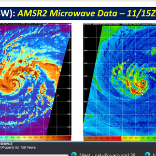
"We are looking at the potential for a short window of a super typhoon classification: 150 mph could be achieved right here as we go into Monday evening, early Tuesday, 150 mph, high end Cat 4, super typhoon," Aydlett said.
"So this is going to be a significant typhoon. It has been the expectation that we're going to be looking at a significant typhoon approaching the Marianas."


Gov. Lou Leon Guerrero and Rear Adm. Brett Mietus anticipate placing Guam and military bases in Condition of Readiness 2 and Tropical Cyclone Condition of Readiness 2, respectively, at 5 p.m. today.
At COR2, the government of Guam, except for essential services, will not operate until COR 4 is announced. For TCCOR 2, JRM is finalizing closing times for the remaining military services, with details released later today.
Officials advise residents to use this time to complete final preparations and limit movement to essential activities.
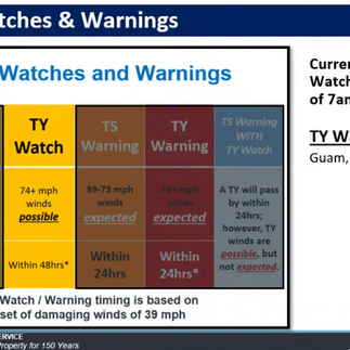
A typhoon watch remains in effect for Guam, Rota, Tinian and Saipan, meaning typhoon conditions, including winds of 74 mph or more, are possible within 48 hours.
Although the latest forecast track has shifted slightly north, residents and visitors of Guam should remain prepared.
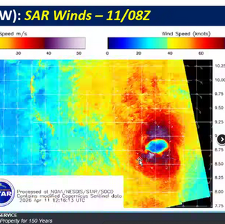
With any shift of the track, Guam can still potentially experience strong category 4 typhoon winds, including 120mph to 130mph winds.
There is no secondary system following Sinlaku being monitored at this time.
Tropical storm force winds of 39 mph or more are anticipated to begin affecting the Marianas Monday evening. Typhoon force winds, of 74 mph or more, remain possible for Guam and Rota Tuesday morning into early Wednesday morning. Typhoon Sinlaku is forecast to pass through the Marianas as a Category 4 typhoon.
Fananu in Chuuk State is currently under a typhoon warning. Chuuk and Ulul in Chuuk State are currently under a tropical storm warning. Ulul, Guam, Rota, Tinian and Saipan are under a typhoon watch.
However, models continue to show a slight spread where Sinlaku’s track could shift slightly north or south, though these ranges are narrowing and will continue to narrow over the next 12-24 hours.
Pohnpei State is still seeing some heavy showers, but this will continue to decrease as Typhoon Sinlaku slowly moves away from Pohnpei. For the Marianas, a windy but relatively dry trade-wind pattern remains in place today, but as TY Sinlaku closes in, conditions will deteriorate sometime Monday morning.
The Port Authority of Guam elevated to Port Heavy Weather Condition Yankee following a declaration by the U.S. Coast Guard at 8 a.m., indicating that tropical storm-force winds are expected within the next 24 hours.
Under Condition Yankee the port is closed to inbound traffic, all vessels heavier than 200 tons must leave the harbor and all cargo operations will cease within 12 hours.
Key port infrastructure and assets have been secured, including the EQMR building, gantry cranes, and all Port load centers.
All hazardous containers, refrigerated containers and remaining containers in the yard have also been secured in preparation for the storm.
“Condition YANKEE signals that we are entering a critical phase of storm readiness,” said Rory J. Respicio, port general manager. “We have taken the necessary steps to secure the Port and are focused on protecting our personnel and infrastructure.”
If conditions continue to intensify, the U.S. Coast Guard is expected to declare Port Heavy Weather Condition ZULU, at which point all port operations will cease.

Subscribe to
our digital
monthly issue