CNMI braces for 'extremely dangerous and life-threatening' situation: Sinlaku predicted to be as destructive as Yutu


By Bryan Manabat
Saipan—More than 300 individuals are sheltering across the Northern Marianas as of Monday, seeking safety and protection as the commonwealth braces for Super Typhoon Sinlaku, which is projected to be as devastating as Super Typhoon Yutu.
At 3:30 p.m today, the National Weather Service issued an "extreme wind" warning for Tinian and Saipan as Sinlaku makes its final approach to the islands with extremely damaging winds of up to 155 mph.
"This is an extremely dangerous and life-threatening situation," NWS said.
"Preparations for the protection of life and property should have already been completed," NWS said in a Facebook post.
CNMI officials urged residents to shelter in place and prepare for rapidly worsening conditions, warning that Sinlaku's most dangerous winds were expected around midnight.
The Commonwealth Utilities Corp. reported an island‑wide power outage on Saipan around 7 a.m., with crews unable to begin restoration work until conditions improve. Officials said high winds and deteriorating weather were already making outdoor operations unsafe.
During an 11:30 a.m. media briefing today, Gov. David M. Apatang said the approaching system required immediate caution and strict adherence to emergency guidance. “As Typhoon Sinlaku continues to approach the Marianas, I urge all members of the community to follow guidance from the Office of Homeland Security, shelter in place and continue all typhoon preparedness measures,” he said.
Apatang emphasized that residents should stay off the roads as winds intensified. “This is not a storm we can afford to take lightly,” he said. He added that emergency services would respond only to critical situations because conditions were becoming unsafe. “Our Commonwealth has faced storms before and we know the importance of acting early, staying calm, and looking out for one another.”
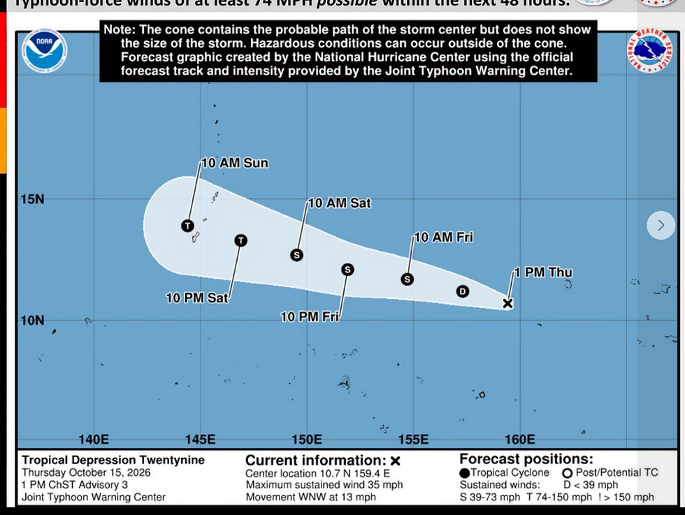
It is expected to maintain its course and speed through Wednesday before making a turn to the north, passing through northern CNMI during the latter half of the week.
Typhoon-force winds of 130 to 155 miles per hour and 175 miles per hour gusts are forecasted for Tinian and Saipan Tuesday night, while Rota will now see strong tropical-storm force winds of 60 to 70 miles per hour with gusts up to 90 miles per hour around the same time period.

The governor urged residents to remain indoors and avoid unnecessary movement. “Stay at the shelter, stay at your house, don’t go around, and be safe,” he said. “Let us work together and weather this storm out together and keep each other safe.”
NWS‑Guam said the storm’s closest approach to Tinian and Saipan is expected late tonight into early Wednesday, with the most severe winds likely within a six‑hour window around midnight. The agency warned of life‑threatening seas, heavy rainfall, and rapidly deteriorating conditions, urging residents to remain sheltered until officials issue an all‑clear.
Apatang said Commonwealth Utilities Corp. crews would begin restoring power and water once it is safe to do so. He also confirmed coordination with federal partners. “They’re ready to throw their support to the Commonwealth once this is clear,” he said.
Asked whether he would remain at the Emergency Operations Center throughout the storm, Apatang said he planned to monitor conditions from home before returning early Tuesday.
He also voiced concern about the storm’s potential strength. “I have a gut feeling that this is going to be like Typhoon Yutu,” he said. “So, we just need to be ready.”
ADVERTISEMENT

Yutu, struck the Northern Mariana Islands on Oct. 24 and 25, 2018, as one of the strongest storms ever recorded to hit U.S. soil. Yutu made a direct hit on Tinian and Saipan with sustained winds of about 180 mph, equivalent to a Category 5 hurricane, causing catastrophic damage across both islands.
The storm destroyed homes, schools, and critical infrastructure, leaving widespread power and water outages and displacing thousands of residents. Yutu remains a defining benchmark for storm severity in the Marianas and is often referenced by officials when assessing the potential impact of new typhoons.
Clement Bermudes, Special Assistant for Homeland Security and Emergency Management, echoed the governor’s warnings, stressing that the storm’s full force had not yet arrived. “The force that you feel from this storm is not even close to what it will be when it gets here,” he said. “We urge you again to please seek safety and do not take this lightly.”

Bermudes urged residents to rely on official information sources, noting that updates come directly from the National Weather Service, the Joint Typhoon Warning Center, and federal partners monitoring the system. He repeated guidance to shelter in place, stay indoors, and move to interior rooms away from windows.
Bermudes said federal and regional partners were prepared to support the CNMI through response and recovery. He added that the most likely track continued to point directly toward the islands, with peak conditions expected between three hours before and three hours after midnight.
While no major incidents had been reported as of the briefing, Bermudes said falling trees and strong winds were already being observed. He noted that the relative lack of serious incidents suggested residents were taking warnings seriously.
“We cannot honestly humanely do anything during the storm,” he said. “We’ve got to ride out the storm until we get the all clear so that we can properly and immediately respond to the needs of the community.”

Subscribe to
our digital
monthly issue